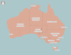
Infrastructure Evaluations
proposals found with keywords: Nil and filters: All
- List View
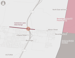
The Camerons Lane Interchange proposal is for the construction of a new interchange on the Hume Freeway in Beveridge.
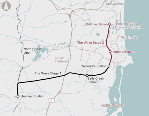
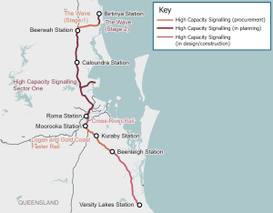
The Wave Stage 2 proposes to deliver a heavy passenger rail extension from Caloundra to Birtinya, as part of the broader Wave program that seeks to provide an integrated public transport connection between Beerwah and the Sunshine Coast Airport.
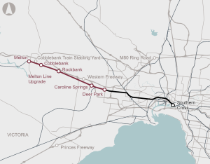
The proposal will deliver new and upgraded platforms to allow longer trains to run on the Melton Line.
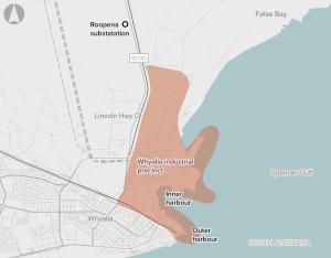
Upgrades to energy, water and port infrastructure at Whyalla to enable the transformation of the steelworks into a low emissions industrial precinct, helping to produce low emissions iron and steel.
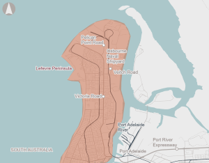
Upgrades to transport, utilities, and social infrastructure on the Lefevre Peninsula, supporting defence capability, housing supply, and industrial growth.
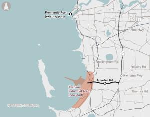
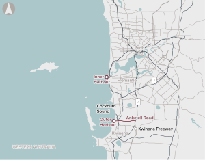
Staged upgrades to Anketell Road between Leath Road and the Kwinana Freeway to enable efficient, reliable and safe freight access to the proposed Westport port development.
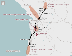
Addressing public transport constraints in Adelaide CBD and improving public transport capacity and connectivity, including extending rail to key growth areas and electrification of the Outer Harbor and Belair rail lines.
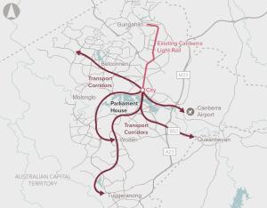
Expanding the public transport network in Canberra, including bus priority corridors and light rail expansion, providing greater connectivity and reducing emissions.

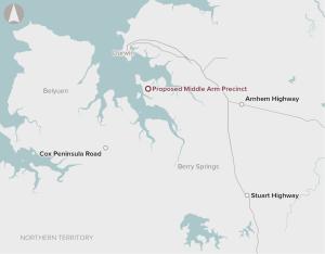
Targeted upgrades supporting safety and reliability of Northern Territory key freight routes, including the Arnhem Highway, Buchanan Highway, Lasseter Highway, Central Arnhem Road, Carpentaria Highway and the Stuart Highway.
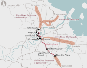
Extending the high frequency, high capacity Metro network, improving access to key destinations such as Brisbane Airport and emerging growth areas, supporting liveability and population growth.
Public transport improvements to strengthen north-south and east-west public transport corridors to better connect residential growth areas with major activity centres.
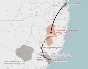
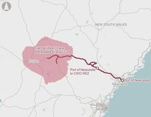
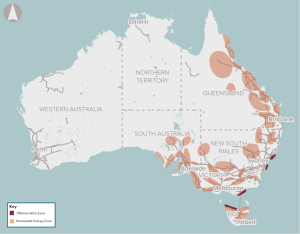
Infrastructure to address port capacity, port access and road network constraints for transporting renewable energy generation components to the New England REZ, supporting the renewable energy transition.
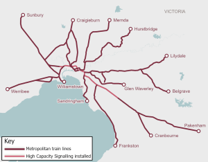
Upgrades to existing signalling and train control technology on the metropolitan rail network with modern, internationally tested intelligent systems, supporting efficient and reliable rail services.
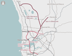
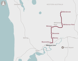
A new suburban radial rail line, supporting housing growth and liveability, by connecting Morley and East Wanneroo to the Joondalup Line to service far northern suburbs, and a potential future Ellenbrook spur line.

Infrastructure to address port capacity, port access and road network constraints for transporting renewable energy generation components to Central Queensland, supporting the renewable energy transition.
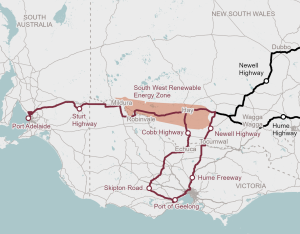
Infrastructure to address port capacity, port access and road network constraints for transporting renewable energy generation components to the South West REZ, supporting the renewable energy transition.
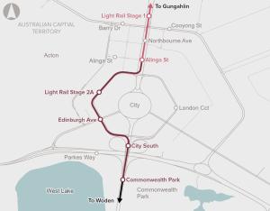
Canberra Light Rail Stage 2A will extend the light rail network from the current terminus at Alinga Street to Commonwealth Park and include three new stops and ‘wire-free’ operations.
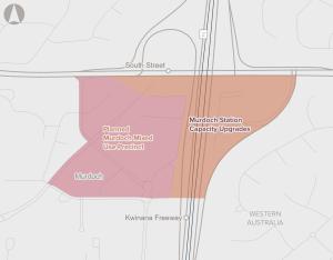
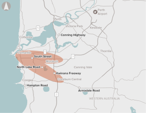
The proposal presents an opportunity to address capacity, access and interchange constraints at Murdoch Station by upgrading station entrances, bus interchange and parking facilities, improving public transport reliability and enabling planned transit‑oriented development in the Murdoch Specialised Activity Centre.
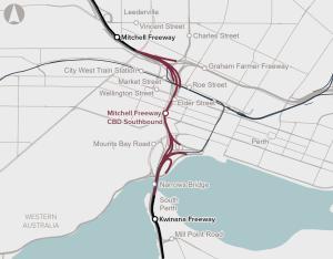
The proposal investigates options to upgrade the Mitchell Freeway to address severe congestion through Perth’s Central Business District. The preferred option is expected to improve travel times and reliability.
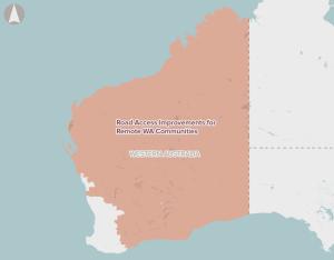
Road capacity and resilience upgrades to improve access to remote Western Australia areas, supporting regional and remote connectivity.
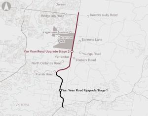
The Yan Yean Road Upgrade Stage 2 will duplicate 5.5 km of Yan Yean Road from Kurrak Road to Bridge Inn Road from two lanes to four lanes.
The proposal supports improved connectivity by linking key suburbs in Melbourne’s north and addressing congestion and safety challenges in a rapidly growing corridor.

The Mamre Road Stage 2 proposal aims to enhance road capacity of a key arterial road in Western Sydney. The proposal will primarily increase the capacity of the road, whilst improving travel times, reducing transport emissions and delivering better road safety outcomes.
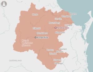
Restoring water security and ensuring long-term dam safety for regional communities and industries in Bundaberg by constructing a new dam wall downstream of the existing structure.
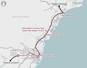
A high speed rail service connecting Newcastle and Western Sydney International Airport via the Central Coast and Sydney, improving connectivity, liveability and enabling housing.
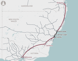
A high speed rail service between Melbourne, Canberra, Sydney and Brisbane, supporting connectivity, liveability and enabling housing.
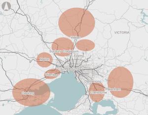
Numerous state Government residential growth corridors have been developed across outer Melbourne and Geelong. This project seeks to evaluate and deliver a range of targeted transport upgrades to increase the capacity of the road network. The detailed evaluation should also consider opportunities for investment in public transport.
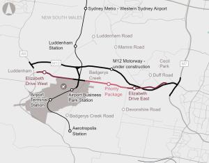
The proposal will enhance the capacity of the transport network by widening Elizabeth Drive from two lanes to four lanes (with future provision for six lanes). The enhancement of this transport corridor includes four bridge replacements and numerous upgraded intersections. Complementing the widening, enhanced public transport and active transport infrastructure is proposed
As a result of the project, resilience of the transport network is…
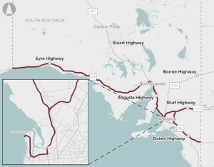
Identification of potential options for upgrades to South Australia’s road network to improve access for High Productivity Vehicles.
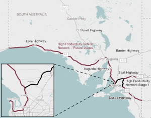
Upgrades to South Australia’s High Productivity Freight Network, supporting improved freight efficiency and road network safety and resilience.
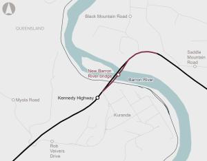
The Barron River bridge is a critical link between Cairns, Kuranda and the Northern Tablelands, supporting daily access for residents, freight and essential services. The existing structure, built in 1963, is experiencing structural deterioration, increasing maintenance needs and safety risks. The business case recommends a new replacement bridge be constructed downstream from the existing bridge.
The upgrade aims to improve traffic flow, travel times and safety for all road users, as well as provide for future improvements to the public transport network.

The project aims to reduce congestion and improve flood resilience by constructing a new bridge, upgrading key intersections, and providing a bypass of Richmond. The existing bridge will remain in its current form and be utilised as an active transport connection.

Queensland's Department of Transport and Main Roads has identified upgrades for the Bruce Highway South Corridor to reduce congestion and improve safety and productivity.
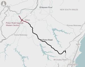
The Picton Road Upgrade (Western Section) involves the upgrade of Picton Road between the Nepean River and Almond Street, Wilton and its interchange with the M31 Hume Motorway.
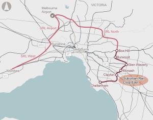
A new 26km mass transit system, with six new underground stations between Cheltenham and Box Hill, supporting housing, liveability and connectivity.
Enabling infrastructure is needed to support the transition to renewable energy sources, such as solar and wind farms and batteries, to meet Australian and NSW Government’s emissions reduction targets.
Expanding public transport coverage, upgrading the road network, and optimisation of freight routes in Greater Hobart, supporting connectivity and productivity.
Rollout of digital signalling and train control technology across the National Network for Interoperability, including trackside and onboard systems, supporting productivity and resilience.

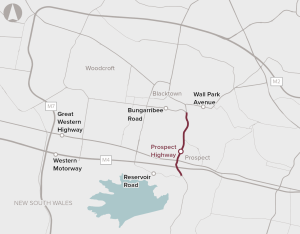
The proposed Richmond Road upgrade between M7 Motorway and Townson Road at Marsden Park as part of North West Growth Centre Road Network Strategy aims to support development in the North West Growth Area.
Upgrades to existing signalling and train control technology on the metropolitan rail network with modern, internationally tested intelligent systems, supporting efficient and reliable rail services.
The transport sector accounts for a large proportion of Australia’s greenhouse gas emissions. Changes to heavy vehicle technology such as use of High Productivity Freight Vehicles (HPFVs) and Low and Zero Emission Heavy Vehicles (LZEHVs) can contribute to meeting the emission targets for the transport sector.
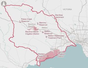
Upgrades to the Western Treatment Plant, Melton Treatment Plant and transfer pipelines supporting recycled water use, environmental outcomes and First Nations’ self-determination within the Werribee water system.
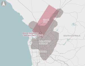
Upgrades to address capacity issues at Bolivar Wastewater Treatment Plant, supporting housing development.
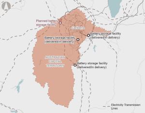
New battery storage capacity that would help reduce the risk of power outages and supply disruptions.
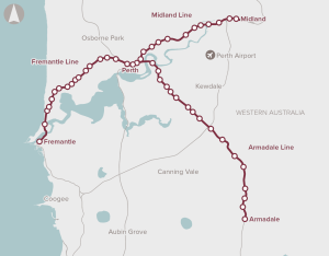
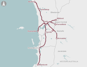
Platform extensions and signalling upgrades across the Armadale, Midland and Fremantle lines, allowing the use of higher capacity six-car trains, supporting efficient rail services and passenger growth.
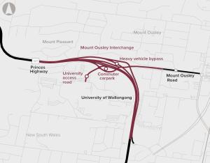
The Mount Ousley Interchange will replace the existing intersection of the Princes Motorway and Mount Ousley Road, improving connectivity, safety and efficiency for those travelling through the gateway to Wollongong.
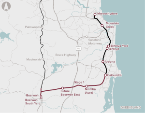
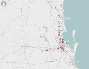
Direct Sunshine Coast Rail Line (Stage 1 – Beerwah to Caloundra)
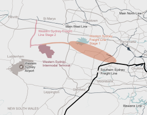
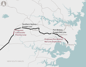
Constructing a dedicated freight rail line between the Southern Sydney Freight Line, a new intermodal terminal at the Mamre Road Precinct and the Main West Line near St Marys, supporting future freight growth and productivity.
Recommended for investment to support the Western Australia Government undertake planning activities for the Armadale, Midland and Fremantle rail lines to enhance capacity and accessibility and improve passenger amenity.
Limited route choice and public transport options, as well as high car dependency will exacerbate existing congestion with population growth.
The M1 Pacific Motorway, Daisy Hill to Logan Motorway proposal aims to address capacity, efficiency and safety issues for the 10-kilometre section of the Pacific Motorway between Daisy Hill and Loganholme through road upgrades and provision of public and active transport infrastructure.
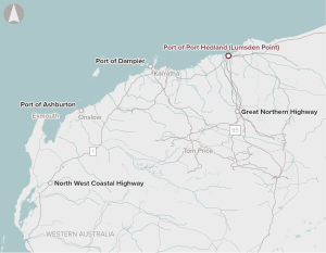
The proposal involves the development of Lumsden Point at Port of Port Hedland, including the provision of an additional deep water general cargo facility in the Pilbara providing for expansion of direct shipping services to the Pilbara.
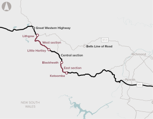
Upgrades to the East and West sections of the Great Western Highway is the first stage of the proposed Great Western Highway Upgrade Program. This stage of the program proposes upgrades between Katoomba and Blackheath, and between Little Hartley and Lithgow. Planning and design for the Central section, between Blackheath and Little Hartley, is continuing and will be the subject of a separate business case.
Common user infrastructure at a new multi-user industrial precinct, supporting export growth and economic diversification.
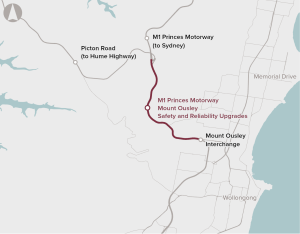
The section through Mount Ousley is a key corridor for movement of freight between the Illawarra region, Greater Metropolitan Sydney via the Princes and Hume Highways (via Picton Road), and southern Sydney industrial precincts such as Moorebank Intermodal Terminal.
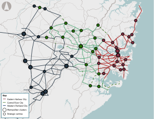
The NSW Government, in partnership with local government, has identified strategic cycleway corridor networks for the Eastern Harbour City, Central River City and Western Parkland City. Robust prioritisation, staging, governance and delivery of these networks will be critical to realising this opportunity. This will need to be underpinned by close collaboration with local governments.
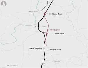
The Tiaro Bypass Project seeks to improve the efficiency, safety and resilience of the Bruce Highway through the development of a bypass to the east of Tiaro.
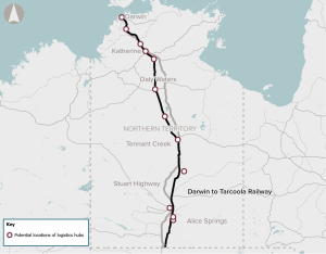
Freight rail and logistics capacity improvements along the Darwin-Tarcoola rail corridor to improve connectivity, supporting efficient movement of goods across the Northern Territory and to national and international markets.
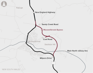
The Muswellbrook Bypass project aims to address existing problems through the development of a bypass of Muswellbrook to the east of the town and Skellatar Hill, starting near Milpera Drive and re-joining the New England Highway north of Sandy Creek Road.
Relocating Western Australia’s primary container port from Fremantle to a new facility at Kwinana to meet future demand, supported by upgraded road, rail, and intermodal infrastructure.
Recommended for investment to support the Western Australia Government undertake planning activities for the Westport program, to provide long-term supply chain capacity for future trade growth in the state.
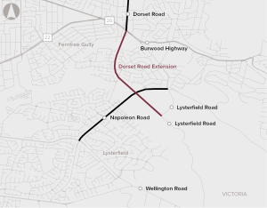
The Dorset Road Extension proposal involves the extension of Dorset Road from Burwood Highway to Lysterfield Road in south-eastern Melbourne, Victoria.
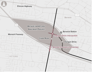
The Monash Roads Upgrade project involves the upgrade of two intersections within the Berwick Health and Education Precinct. It is expected to provide improved access to local employment and services, as well as reduced congestion and delays.
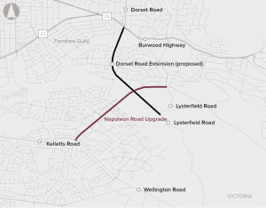
The Napoleon Road Upgrade proposal involves the duplication of Napoleon Road from Lysterfield Road to Kelletts Road in Rowville, in Melbourne's outer south-east.
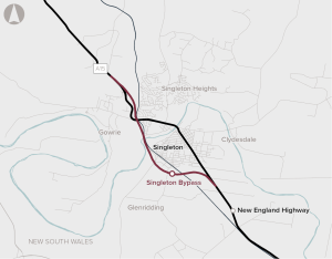
The New England Highway Singleton Bypass proposal aims to improve safety, travel times and travel variability for traffic on the New England Highway travelling through Singleton and will facilitate movement of heavy freight vehicles travelling on this section of the New England Highway.
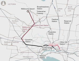
A new passenger rail line supporting connectivity between Melbourne Airport, the CBD and regional rail network, with new stations at Melbourne Airport and Keilor East and upgrades at Sunshine Station.
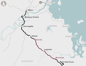
The Logan and Gold Coast Faster Rail (Kuraby to Beenleigh) proposal includes increasing rail capacity, modernised rail systems, upgraded train stations and road access, a new stabling facility, level crossing removals and a dedicated active transport facility.
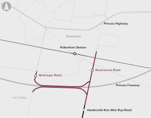
The Pakenham Roads Upgrade package is comprised of the McGregor Road Interchange Upgrade project and the Racecourse Road Upgrade project. The proposal includes duplication of Racecourse Road and upgrade of the McGregor Road and Racecourse Road freeway interchanges.
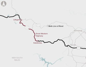
The proposal is to complete the duplication of the Great Western Highway. Over 100 km of the highway has been duplicated so far, leaving a 33 km gap between Katoomba and Lithgow.
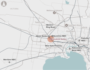
Opportunity to redevelop Sunshine Station and the surrounding precinct as a major future PT interchange linking Melbourne Airport, the CBD and regional Victoria.
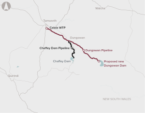
The Dungowan Dam and Pipeline is a proposal to increase town water supply for Tamworth and sustain the reliability of water for agriculture across the Peel Valley.
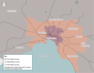
Melbourne’s monocentric urban form is constraining the economic potential of Melbourne’s middle and outer suburbs.
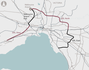
Future stages of the Suburban Rail Loop mass transit system, including SRL North and SRL West, supporting housing and jobs growth in Melbourne’s inner and outer suburbs.
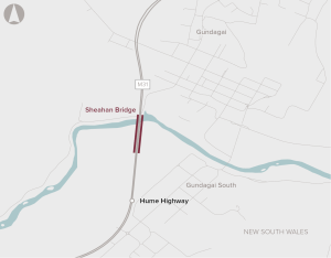
Upgrades to the northbound Sheahan Bridge at Gundagai to enable High Productivity Vehicle movements on the Hume Highway, supporting freight productivity.
Insufficient or inadequate infrastructure to allow drivers of heavy vehicles to stop and rest across NSW.
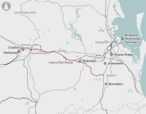
Infrastructure to ensure interoperability between the Country Regional Network and Inland Rail to maximise productivity and efficiency of freight movements from regional NSW to domestic and export markets.
Recommended for investment to support the New South Wales Government to undertake planning and development activities for improving transport connectivity to support the growth of the Greater Parramatta and Olympic Peninsula precincts.
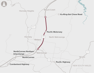
Extreme congestion on the M1 Pacific motorway between the existing North Connex portal and Mt Colah.
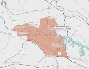
Opportunity to co-ordinate delivery of infrastructure to support sustainable growth in Greater Parramatta and the Olympic Peninsula.
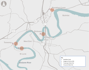
Opportunity to address challenges associated with congestion, forecast population growth and geographical limitations by improving active transport networks across the Brisbane River.
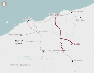
Limited energy transmission and storage infrastructure across the Pilbara in Western Australia.
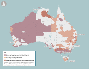
As the frequency and severity of natural disasters increase due to climate change, early warning systems present an opportunity to improve the safety and wellbeing of communities in high-risk zones.
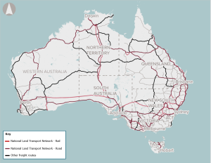
During severe natural disasters, regional and remote communities are often isolated due to corridor closures on the National Land Transport Network (NLTN).
Additional intermodal terminal capacity in South East Queensland to support forecast freight growth and service future Inland Rail trains, supporting freight productivity and resilience.
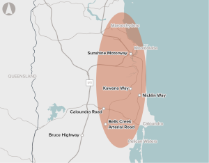
Strong population growth, a constrained road network, and limited transport options are contributing to congestion between Caloundra and Maroochydore.
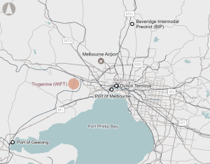
Development of the Western Intermodal Freight Terminal in Melbourne’s west supporting future freight growth and productivity, connecting to the proposed Outer Metropolitan Ring Rail South, Inland Rail and the national freight rail network.

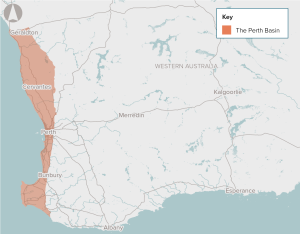
Increasing coastal erosion and inundation risks across Western Australia.
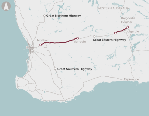
Deteriorating road conditions, increasing travel times, aging bridges and relatively high road maintenance costs on the Great Eastern Highway.
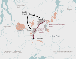
Opportunity to upgrade and extend irrigation channels to expand irrigated crops in the Ord River Irrigation Area in North-West Western Australia and the Keep River Plains in North-East Northern Territory.
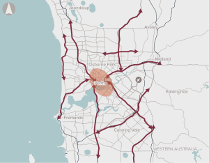
Worsening road congestion, high private vehicle use and a lack of dedicated active transport connections that link key strategic centres in Perth.
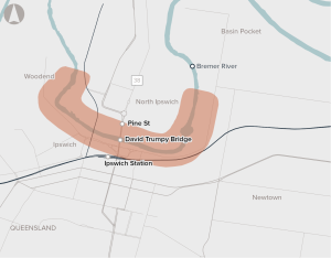
Strong forecast population growth and a single river crossing is expected to place increasing pressure on the transport network in Ipswich.
Recommended for investment to support the New South Wales Government’s revitalisation of the precinct to enhance accessibility and safety, improve transit capacity and connectivity and improve passenger and visitor experience.
Recommended for investment to support the New South Wales Government undertake planning activities to define the infrastructure required to support the deployment of zero-emissions buses across the state.
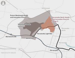
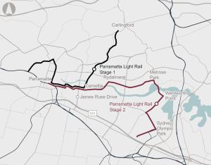
Opportunity to redevelop Government-owned land in Parramatta North, capitalising on the redevelopment of Westmead and the Parramatta Light Rail.
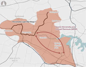
Poor connectivity to and from precincts in Greater Parramatta and the Olympic Peninsula, limiting ease of movement.

Infrastructure supporting the rollout and operation of ZEBs, such as depot upgrades, charging infrastructure and power grid upgrades, that would reduce public transport emissions.
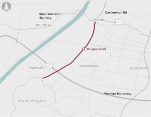
High levels of congestion and safety risks on Mulgoa Road in Western Sydney.
Infrastructure supporting the rollout and operation of ZEBs, such as depot upgrades, charging infrastructure and power grid upgrades, that would reduce public transport emissions.
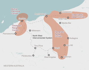
New common-use transmission infrastructure to connect areas of high renewable energy resource potential with regional communities and major export industries in the Pilbara region, supporting the renewable energy transition.
Upgrades to narrow sections, strengthening and replacing bridges, and improving flood-prone segments to improve regional and remote connectivity.
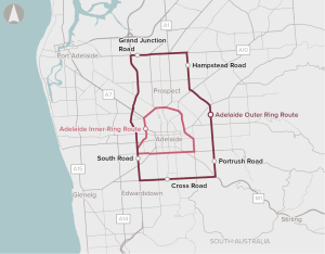
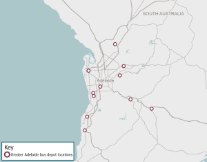
Increasing population growth in Adelaide is expected to increase congestion and travel times in the suburbs surrounding inner-Adelaide, to the CBD, as well as impact freight productivity and safety for pedestrians and cyclists.
There is a significant opportunity to develop supply chains in Australia to meet potential demand in domestic and export markets.
Limited high priority public transport services to connect employment centres and tourism hubs with major residential and commercial developments.
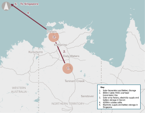
A proposal to supply renewable energy to Asia via a sub-sea cable
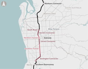
The North-South Corridor: Torrens to Darlington proposal is for the construction of a new 10.5 kilometre six-lane connection between the River Torrens and Darlington to complete Adelaide’s North-South Motorway. Tunnels make up over 60 per cent of the length of the proposed motorway connection.
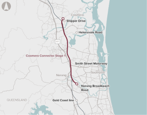
The Coomera Connector Stage 1 proposal is for an alternative transport route to the M1 for local trips between Coomera and Nerang.
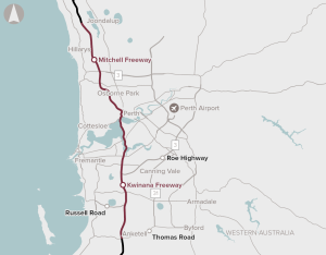
Widening the Mitchell and Kwinana Freeways and implementing Intelligent Transport System technologies.
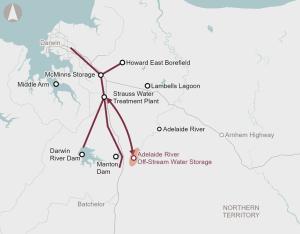
Recommended for investment to support the Northern Territory Government to undertake planning work to demonstrate how the Adelaide River Off-Stream Water Storage project can provide a water source necessary for the growth and prosperity of the territory beyond 2030.
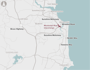
Traffic demand is exceeding the capacity of the Mooloolah River Interchange and the surrounding road network during peak periods.
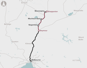
The Shepparton Line Upgrade (Shepparton Corridor Upgrade Stage 3) proposal is envisaged to deliver faster and more reliable services between Shepparton and Melbourne by providing track and signalling upgrades, and enhanced stabling.
There is limited provision of regional-level sporting facilities in the outer metropolitan areas of Perth, reflecting past undersupply that has not kept up with high population growth.
The proposal includes widening Tonkin Highway from four to six lanes and upgrading the intersections at Hale Road, Welshpool Road and Kelvin Road, providing benefits to north-south commuters and freight traffic around the Perth Airport Industrial Hub.
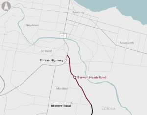
The Barwon Heads Road Duplication proposal seeks to duplicate a four kilometre section of Barwon Heads Road between Settlement Road and Reserve Road. The proposal includes construction of a new bridge over the rail line at Marshall and remove the level crossing, upgrade multiple intersections, a shared path, new street lighting and road signage.
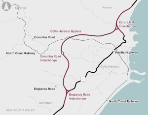
The Coffs Harbour Bypass proposal is for an upgrade of the Pacific Highway at Coffs Harbour. The proposal includes the construction of a new 12 kilometre bypass from south of the Englands Road intersection to Korora Hill and a 2 kilometre upgrade of the existing Pacific Highway between Korora Hill and Sapphire.

The Creative Industries, Business and Technology City Campus is a proposed new city campus in the Perth CBD.
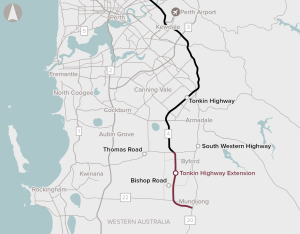
The Tonkin Highway Extension proposal involves the construction of a 14 km extension of the Tonkin Highway from Thomas Road to the South Western Highway.
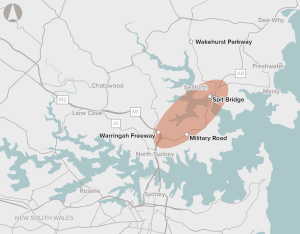
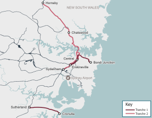
A motorway connection from the Warringah Freeway and the Gore Hill Freeway at Artarmon to Balgowlah and Killarney Heights, and an upgrade of the Wakehurst Parkway.
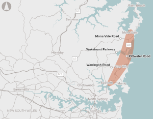
This proposal is specifically focused on the section of the A8 corridor between Seaforth and Mona Vale. Specific sections that have been identified for potential works include the Mona Vale complex, Narrabeen complex, Dee Why town centre, Brookvale Oval, and the intersection between Condamine Street and Pittwater Road.

The Newcastle Inner City Bypass – Rankin Park to Jesmond project involves the construction of a 3.4 km section of the Newcastle Inner City Bypass. Bypassing the existing route is intended to reduce congestion and travel times, and improve road safety.
The Rockhampton Ring Road proposal is part of the Bruce Highway Upgrade Program. It is designed to provide an alternative to the existing section of the Bruce Highway through Rockhampton.
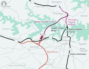
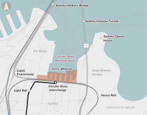
The Sydney Harbour Bridge and Sydney Harbour Tunnel are critical road links for Sydney’s transport system. Demand for these road links is expected to grow, increasing congestion.
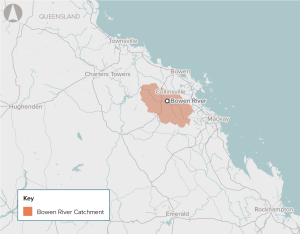
A constrained water supply is limiting the growth of agricultural, industrial and mining productivity in and adjacent to the Bowen Basin. Increasing the water supply can unlock additional agricultural land and facilitate a more robust water trading market with potential flow-on price reductions for mining and industrial water users.
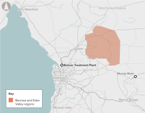
The River Murray is currently the major source of irrigation water to the Barossa Valley Region. Smaller volumes of groundwater are available, although the quality in some areas is not fit-for-purpose or sufficient to meet increasing industry demand.
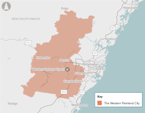
The business case is for a new railway line to service Greater Western Sydney and the new Western Sydney Airport. It includes new stations at the Western Sydney Airport and the Western Sydney Aerotropolis, as well as fully-automated driverless trains.
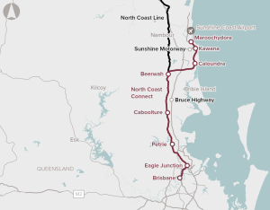
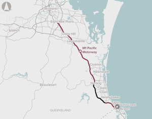
Developed as part of the Australian Government’s Faster Rail Prospectus process, the North Coast Connect proposal is designed to provide a faster rail connection between Brisbane and the Sunshine Coast.
Providing digital infrastructure would enable the adoption of technologies that reduce travel times, reduce resource use and emissions, improve health and provide more ways for community members to access up to date information about services and developments in their city.
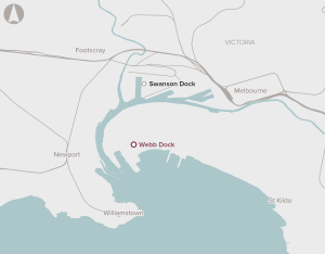
The number of containers handled by the Port of Melbourne is forecast to grow from 3 million twenty-foot equivalent container units (TEUs) in 2019 to close to 9 million TEU by 2050. The majority of this growth in containers will need to be delivered at Webb Dock. However, with the existing infrastructure, all freight to and from Webb Dock is carried by road. This results in increased congestion on the surrounding road network.
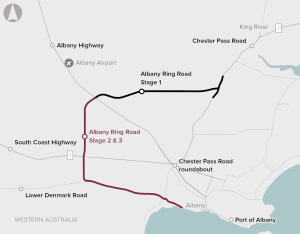
This business case proposes an alternative freight access route to the Port of Albany. The project would involve a ring road around the urban areas of Albany, which aims to improve freight efficiency and help separate freight, local and tourist traffic within Albany.
The business case is for removing six level crossings on the inner Armadale Line. The project aims to improve safety and reduce congestion at the level crossings, as well as improving station precincts and public open space.
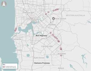
There are 30 level crossings on Perth’s electrified passenger rail network, which services 72 stations across five lines. Level crossings provide important connectivity for vehicles, cyclists and pedestrians across train lines, but also result in road congestion and safety risks.
The realignment of the Sturt Highway through the Truro Hills, including a bypass of the town of Truro, to improve safety and allow use of High Productivity Vehicles on the highway.
South East Queensland’s Citytrain network includes 65 level crossings. Most of these level crossings are in urban environments, which can lead to congestion and safety issues.
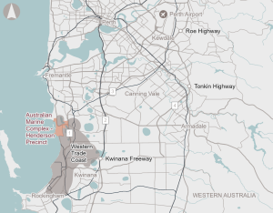
Upgrades to enabling infrastructure for the Henderson Defence Precinct and the Australian Marine Complex, supporting regional economic growth and defence capability.
Upgrade 3.6 km of highway to a four-lane divided carriageway.

The proposal is for a mix of infrastructure and non-infrastructure responses (such as demand management) to efficiently meet agreed service standards for water security in Australia’s towns and cities.
Water supply and demand management interventions to provide additional sources of climate-independent potable water supporting industry and population growth.
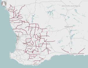
The program is for assessing and prioritising sections of the Wheatbelt Secondary Freight Network.
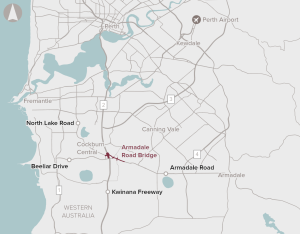
The Armadale Road/Beeliar Drive interchange is experiencing severe congestion and traffic volumes are growing through the Midgegooroo Avenue/Beeliar Drive intersection. Safety is also a significant challenge, with Armadale Road between Cockburn and Armadale ranked by the Royal Automobile Club of Western Australia as the state’s sixth riskiest road.
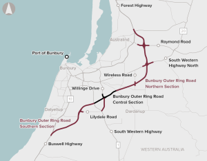
Bunbury is one of the fastest growing regional cities in Australia. Its population is projected to grow by 1.6% on average from 175,900 in 2016 to 206,640 by 2026. Two of Bunbury’s major industries, mining and tourism, place pressure on the local road network, with the road network near the Port of Bunbury carrying a mix of freight and light-vehicle traffic (including local, regional and tourist trips).
Potential options to address the proposal include: increasing shared use of the existing transmission network upgrading existing regional networks to allow faster digital connections investing in new transmission networks.
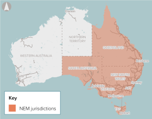
The National Electricity Market (NEM) will require significant investments in dispatchable energy storage to support growing renewable energy generation and the future retirement of coal-fired generators.
Enabling digital health technologies in regional and remote areas of Australia can improve equity of access and outcomes, reduce costs associated with delivering health care and reduce avoidable hospitalisations.
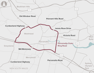
Options for improving capacity of Parramatta's Outer Ring Road
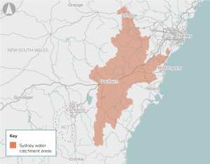
The proposal aims to deliver long-term water security, water quality, amenity, recreation and public health outcomes for Greater Sydney. Potential options to address the proposal include better-use and new infrastructure investments, as well as non infrastructure responses such as demand management to efficiently meet this need.
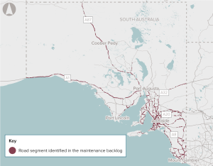
There is a large and increasing backlog of maintenance on the national and state-owned roads in South Australia, which is increasing costs for road users.
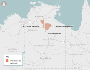
The Beetaloo Sub-Basin has been identified by industry as containing a significant quantity of gas that could be within economically feasible depths to extract.

The Melbourne to Adelaide freight rail corridor cannot carry double-stacked containers. This increases costs for operators and impacts on freight rail between Melbourne and Adelaide, and also to Perth.
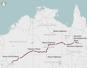
The Outback Way is the only direct route that connects Western Australia to Queensland, and is an important piece of national transport infrastructure. The inconsistent and poor condition of the road leads to long and unreliable travel times and higher safety risk for road users. Around half of the route is unsealed.
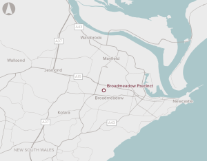
There is an opportunity to redevelop an existing sports and entertainment precinct five kilometres from the Newcastle CBD.
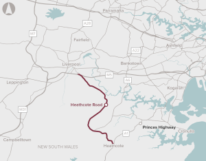
Heathcote Road is a 24.5-kilometre arterial road connection between the M5 Motorway and A1 Princes Highway. The current road capacity and design is leading to congestion, poor reliability and safety issues, particularly around key intersections. Several sections of Heathcote Road have minimal overtaking opportunities.
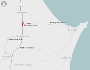
The proposal is for capacity improvements on the M1 Pacific Motorway interchange to Byron, which could include a range of configurations.
The current limitations of the terminal and runway impacts inbound and outbound flights to domestic destinations and restricts access to international destinations in Oceania. This leads some passengers to commute to and from Sydney Airport for air travel.
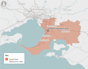
Climate change, population growth and ageing assets present potential longer-term water security problems for Melbourne. Climate-independent water supply sources can help address the problem. Melbourne’s Eastern Treatment Plant produces over 130 billion litres of recycled water each year. Currently, about 95% (123 billion litres) of this water is treated and safely discharged into the Bass Strait.
There is poor access to digital services in the regional and remote areas of Western Australia due to a lack of fit-for-purpose digital infrastructure and low service performance of existing infrastructure.
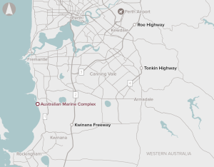
The AMC is an integrated marine and industrial fabrication complex established to support the construction, development and maintenance of major projects and assets in the oil and gas, mining and shipbuilding industries. The existing complex is home to over 150 businesses. However, there is limited infrastructure capacity at the complex and the common user facility to support growing demand.
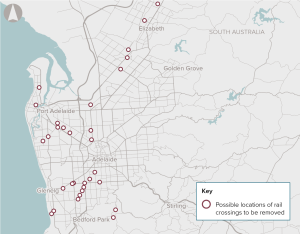
The proposal could be addressed through a program to identify, prioritise and remove level crossings in Adelaide.
A new, climate-independent water source for South Australia's Upper Spencer Gulf and Far North regions supporting growth in industrial and agricultural activities, including mining.
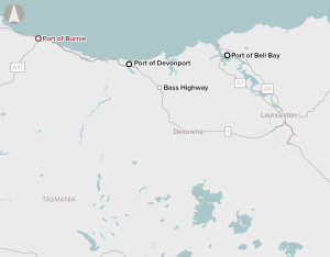
Upgrades to the Port of Burnie, Tasmania’s only multi-use seaport, to enhance bulk and containerised shipping capacity.
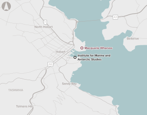
In its existing condition, the port cannot accommodate the Australian Antarctic Division’s new purpose-built icebreaker, RSV Nuyina. It also cannot accommodate the Oasis passenger cruise vessels, impacting on tourism.
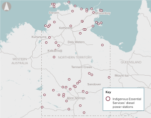
Replacement of ageing diesel generators in 72 remote communities across the Northern Territory with a mix of renewables, hybrid generation and battery storage systems, supporting energy security and Closing the Gap outcomes.
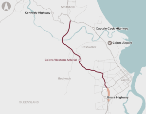
The Cairns Western Arterial Road provides important access for commuter, tourism and freight traffic. Approximately 42,000 vehicles use the busiest sections of the road each day, resulting in heavy congestion and queuing on the undivided sections of the road and at its intersections.
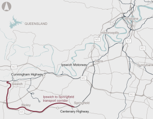
New high capacity transport service between Ipswich and Springfield, supporting regional connectivity.
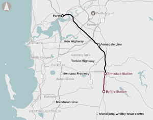
The business case is to extend the Armadale Line approximately eight kilometres south to Byford. This is to support and provide public transport access to the high-growth suburb of Byford.
The Bridge is ageing and has not undergone a significant upgrade since construction. The proposed project will include structural upgrades that are required to meet relevant design standards for load capacity, traffic lane width, safety barriers, and active transport corridor width.
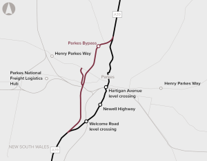
The Project is a 10.5 kilometre western bypass of Parkes, including bridges over existing railway lines, connections to the Parkes Special Activation Precinct, and upgrades to local roads. The project has an estimated capital cost of $175 million (P50, outturn costs) and is expected to be completed by 2024.
The National Electricity Market (NEM) will require significant new grid-scale renewable energy generators to replace retiring thermal generation facilities.
The business case is for the delivery of upgrades to the Gippsland Line to deliver additional services, improved reliability and resilience, and improved passenger experience.
Upgrades to existing signalling and train control technology on the metropolitan rail network with modern, internationally tested intelligent systems, supporting efficient and reliable rail services.
Develop options to address demand for transport services in Melbourne's outer northern suburbs.
Options analysis for the section between Daisy Hill and Loganholme aligns with the requirements of the Infrastructure Australia Assessment Framework.
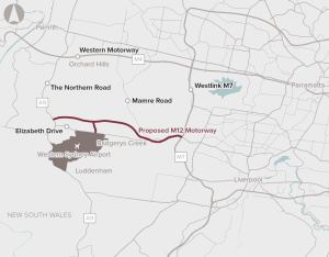
The M12 Motorway will be a new 16-kilometre dual-carriage motorway an is part of the Western Sydney Infrastructure Plan. It will connect the Westlink M7 Motorway to The Northern Road, which is a major north–south corridor and also a component of the Western Sydney Infrastructure Plan.
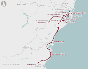
This project is Stage 2 of the multi-stage More Trains More Services (MTMS) Program to increase rail capacity across the Sydney network. MTMS Stage 2 will include enabling works on the T4 line.
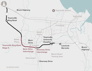
This is a proposal for the duplication of a 6 kilometre two-lane section of the Bruce Highway between Vickers Bridge and Shaw Road in the south west of Townsville.
Potential improvements include upgrades to the existing road network, improving bus service frequency and reliability or introducing new modes such as bus rapid transit or rail.
Upgrades to existing signalling and train control technology on the METRONET rail network with modern, internationally tested intelligent systems, supporting efficient and reliable rail services.

Capacity for Brisbane's northern transport corridors to support residential growth in northern Brisbane, combined with employment growth primarily in the Brisbane CBD.
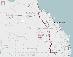
Capacity and safety improvements on Queensland’s Inland Freight Route, from Mungindi (at the New South Wales border) to Charter Towers in North Queensland.
That make up a disproportionate amount of crashes on Queensland's road network.
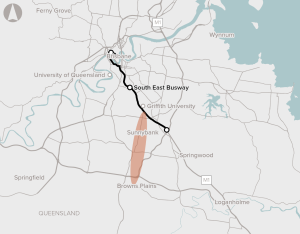
Improving public transport connectivity along the 14km major transport corridor between Browns Plains and the South East Busway.
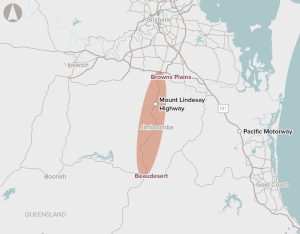
Capacity and safety issues along the corridor between Browns Plains and Beaudesert.

The initiative is for a mix of infrastructure and non-infrastructure responses (such as demand management) to efficiently meet agreed service standards for water security in Australia’s towns and cities.
The proposal is for a proactive infrastructure strategy in advance of the inundation risks materialising. Involving engagement with all levels of government, the strategy will need to consider which areas should be protected for continued use, modified to accommodate floods, or withdrawn from altogether.
The proposal is for addressing the road maintenance backlog across local, state and national roads.
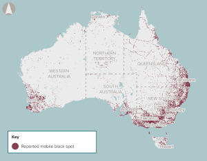
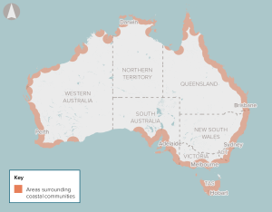
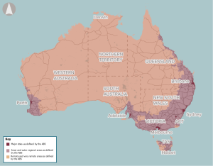
The proposal is to improve the availability and quality of mobile services in certain regional and remote areas.
The proposal is for infrastructure improvements which enable larger vessels access to Australian ports on the east coast. This could require channel deepening at existing ports, development of new port locations and enhanced land-side access infrastructure at ports.

The proposal proposes a strategy that prioritises investment based on the goals of improving productivity and safety on regional Queensland roads, and sustaining regional communities. The proposal includes improvements to address safety, surface issues, flooding, bridge strength and width, road alignments, widening and pavement sealing.
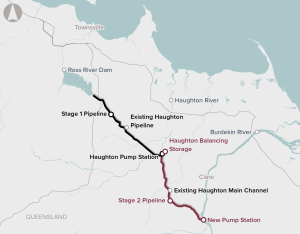
The business case considers constructing a pipeline between the Burdekin River and the Haughton pump station to supplement water supply for Townsville. A stage 1 pipeline, between the Haughton pump station and the Ross River Dam (via the Toonpan Outlet), is currently under construction.
The project will provide the capacity required to meet forecast rail demand generated by the Moorebank Intermodal Terminal, Enfield Intermodal Terminal, the St Marys Intermodal Terminal (from 2022), and future terminals, including a site planned near Western Sydney Airport.
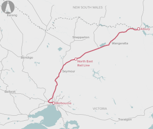
The North East Rail Line project is to upgrade rail track from Melbourne to Albury/Wodonga to a Victorian Class 2 performance standard. It includes upgrading supporting rail infrastructure.
The Port of Newcastle’s Multi-purpose Deepwater Terminal proposal is for the development of a new contained terminal at its Mayfield site.
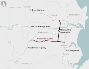
The Walkerston Bypass project includes a 10.4 kilometre realignment of the Peak Downs Highway, from west of Walkerston to the Mackay Ring Road at Stockroute Road.
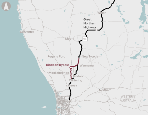
The proposed Bindoon Bypass would reduce vehicle kilometres travelled by enabling triple road trains to travel along the entire length of the corridor, thereby avoiding the need to stop and decouple at Wubin.
The proposal is for a structured program approach to addressing the maintenance backlog for the NLTN in Queensland.
This initiative complements the national High Priority Initiative for Regional road network safety improvements. It involves treatments such as sealing shoulders, wide centre lines and audio tactile line marking to attain a safer road cross section on the State’s Highway and Main Roads regional and rural road network.
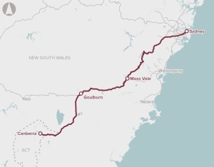
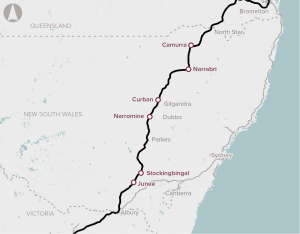
Upgrades to the Sydney-Canberra rail corridor, supporting quicker and more frequent rail services.

The proposal is for a program of works to make the corridor safer, and more efficient and accessible.

The proposal is to develop the South Creek Catchment in a way that maximises the opportunity for integrated land use and water cycle planning, to enhance the liveability and environmental quality of the area.
The proposal involves the provision of dedicated cycling infrastructure for key routes in Inner Melbourne to reduce congestion and improve safety and health outcomes.
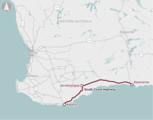
Upgrades to the South Coast Highway between Albany and Esperance, supporting connectivity and road safety.
The proposal involves network, generation and storage investment in the SWIS.

The proposal is for a national facility to develop and test new technologies with the potential to improve operational performance, as well as potentially increase process reliability and reduce production costs.
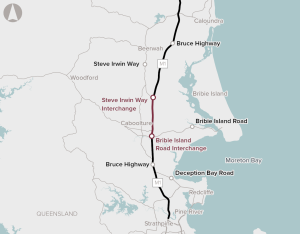
The Bruce Highway, Bribie Island to Steve Irwin Way Project aims to widen the Bruce Highway from four to six lanes between Caboolture and Steve Irwin Way.
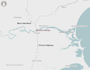
Construct a new four-lane bridge to the west of the existing bridges at Nowra
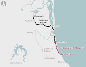
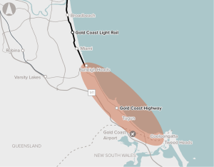
Extend the existing Gold Coast Light Rail line from Broadbeach South to Burleigh Heads
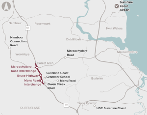
Upgrade the Maroochydore Road interchange, including ramp upgrades and new service roads
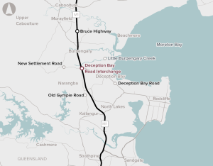
New parallel bridges over the Bruce Highway, near Deception Bay, to increase the capacity of the intersection and improve traffic flow
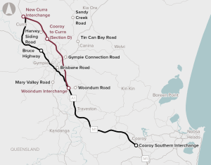
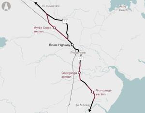
Upgrade 26 kilometres of the Bruce Highway between Cooroy and Curra to bypass Gympie
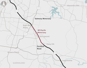
The proposed project would provide additional road capacity by widening an 8.5 km northbound section of the motorway between the Gateway Motorway (at Eight Mile Plains) and Paradise Road (at Daisy Hill),and provide southbound capacity improvements between Rochedale Road and Fitzgerald Avenue (in Springwood).
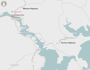
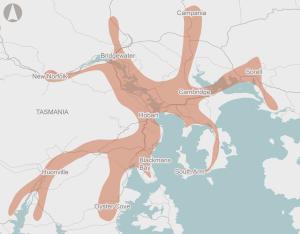
The proposal involves the development of an alternative Derwent River crossing due to capacity constraints on Bridgewater Bridge.
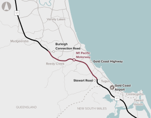
This business case proposes widening both directions of the M1 Pacific Motorway between Varsity Lakes Interchange and Tugun Interchange from four lanes to six lanes, and upgrading the majority of interchanges.
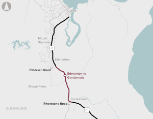
Creating a four-lane highway between Edmonton to Gordonvale and significantly reducing interfaces with properties, the North Coast Railway and arterial roads.
Relocate existing campuses in Launceston and Burnie to new inner-city locations.
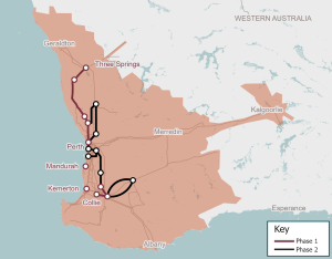
New transmission infrastructure to connect areas of high renewable energy potential with consumers and industries across south west Western Australia, supporting the renewable energy transition.
A national program of works to improve safety on regional roads.
Introduction of modern road safety infrastructure technology and features, to improve road safety at high-risk locations.around NSW.