Infrastructure Evaluations
proposals found with keywords: Nil and filters: All
- List View
- Map View

The project aims to upgrade the Intelligent Transport System (ITS) on the Monash Freeway, in order to manage traffic flows, including motorway entry, lane use and driving speeds.

The program, led by a coalition of state governments, seeks to incorporate intelligent transport solutions comprising information, communication and control systems, into urban motorway networks. This submission comprises updated information and works for Victoria.

This project replaces Queensland’s prior Eastern Busway project, and seeks to modify existing road space to provide new bus lanes in the northern and eastern corridors of Brisbane.

The project is designed to provide bus priority measures along the existing road corridors, bus priority infrastructure at intersections and upgrades to eight identified stops or interchanges to improve amenity and ticketing efficiency.

The project involves the construction of a 15.6km road to link the port to employment hubs and the resource production regions of South Australia. It also aims to improve the efficiency of the freight network by preserving an adjacent freight rail track corridor between Port Adelaide and the north.

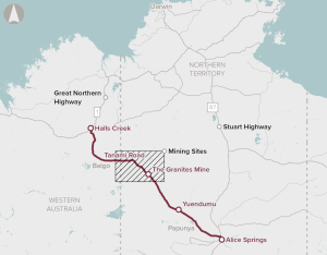
Upgrades to improve flood immunity and resilience for the Tanami Road between the Stuart Highway north of Alice Springs, and the Great Northern Highway at Halls Creek.

The initiative involves the creation of a fully segregated, two-way dedicated busway between the University of Queensland and Capalaba.

Managed motorways is the term used to describe an integrated package of intelligent transport system tools incorporated in and alongside urban motorways. The governments of Queensland, New South Wales, Victoria, Western Australia and South Australia jointly developed the business case.

The initiative is nationally significant as it addresses productivity improvement by enabling freight train lengths to increase to 1800m.

The project involves the upgrade of the existing road link between the Federal Highway and the Monaro Highway and consists of construction of an 11.5 km limited‐access four‐lane road and grade separated interchanges with the Federal Highway, Fairburn Avenue and Monaro Highway.

The proposed project involved the development of conveyors, stockpile storage facilities, and a second rail dump station for discharge of mining products.

Construction of a port at Oakajee

The Coomera Connector Future Stages proposal aims to deliver a new six-lane motorway between Loganholme and Coomera, supporting the existing investment of Stage 1 to complete the Coomera Connector.

Canberra Light Rail Stage 2A will extend the light rail network from the current terminus at Alinga Street to Commonwealth Park, and include three new stops and ‘wire-free’ operations.

The Wave Stage 2 proposes to deliver a heavy passenger rail extension from Caloundra to Birtinya, as part of the broader Wave program that seeks to provide an integrated public transport connection from Beerwah to the Sunshine Coast Airport.

Anketell Road Upgrades Stages 1a and 1b form part of the broader Westport program, which is progressing the development of a new, long‑term container port at Kwinana to replace the inner‑city Fremantle Port.
Subject to agreement of content with proponent.